


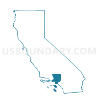
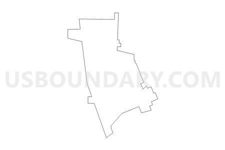
Voting District 55088, Los Angeles County, California
About
Outline

Summary
| Unique Area Identifier | 533892 |
| Name | Voting District 55088 |
| County | Los Angeles County |
| State | California |
| Area (square miles) | 6.97 |
| Land Area (square miles) | 6.97 |
| Water Area (square miles) | 0.00 |
| % of Land Area | 99.95 |
| % of Water Area | 0.05 |
| Latitude of the Internal Point | 34.17845320 |
| Longtitude of the Internal Point | -118.34228770 |
Maps


Graphs
Select a template below for downloading or customizing gragh for Voting District 55088, Los Angeles County, California


Neighbors
Neighoring Voting District (by Name) Neighboring Voting District on the Map
- Voting District 33033, Los Angeles County, CA
- Voting District 33039, Los Angeles County, CA
- Voting District 33045, Los Angeles County, CA
- Voting District 33048, Los Angeles County, CA
- Voting District 33051, Los Angeles County, CA
- Voting District 33054, Los Angeles County, CA
- Voting District 33057, Los Angeles County, CA
- Voting District 33156, Los Angeles County, CA
- Voting District 33192, Los Angeles County, CA
- Voting District 33270, Los Angeles County, CA
- Voting District 55076, Los Angeles County, CA
- Voting District 55091, Los Angeles County, CA
- Voting District 55097, Los Angeles County, CA
Top 10 Neighboring County Subdivision (by Population) Neighboring County Subdivision on the Map
- Los Angeles CCD, Los Angeles County, CA (2,504,251)
- San Fernando Valley CCD, Los Angeles County, CA (1,771,545)
Top 10 Neighboring Place (by Population) Neighboring Place on the Map
Top 10 Neighboring Unified School District (by Population) Neighboring Unified School District on the Map
Top 10 Neighboring State Legislative District Lower Chamber (by Population) Neighboring State Legislative District Lower Chamber on the Map
- Assembly District 38, CA (505,909)
- Assembly District 39, CA (442,796)
- Assembly District 42, CA (431,038)
- Assembly District 43, CA (421,848)
Top 10 Neighboring State Legislative District Upper Chamber (by Population) Neighboring State Legislative District Upper Chamber on the Map
- State Senate District 20, CA (886,558)
- State Senate District 21, CA (855,013)
- State Senate District 26, CA (848,039)
Top 10 Neighboring 111th Congressional District (by Population) Neighboring 111th Congressional District on the Map
- Congressional District 27, CA (684,496)
- Congressional District 28, CA (660,194)
- Congressional District 29, CA (642,138)
Top 10 Neighboring Census Tract (by Population) Neighboring Census Tract on the Map
- Census Tract 3116, Los Angeles County, CA (7,249)
- Census Tract 3109, Los Angeles County, CA (6,870)
- Census Tract 3117, Los Angeles County, CA (6,137)
- Census Tract 3101, Los Angeles County, CA (5,849)
- Census Tract 3106.01, Los Angeles County, CA (5,716)
- Census Tract 3115, Los Angeles County, CA (5,633)
- Census Tract 3108, Los Angeles County, CA (4,909)
- Census Tract 1253.10, Los Angeles County, CA (4,750)
- Census Tract 1231.04, Los Angeles County, CA (4,596)
- Census Tract 1230.10, Los Angeles County, CA (4,580)
Top 10 Neighboring 5-Digit ZIP Code Tabulation Area (by Population) Neighboring 5-Digit ZIP Code Tabulation Area on the Map
- 91605, CA (56,343)
- 91352, CA (47,807)
- 91606, CA (44,958)
- 91601, CA (37,180)
- 91505, CA (30,778)
- 91504, CA (24,939)
- 90068, CA (22,286)
- 91506, CA (18,904)
- 91602, CA (17,473)